
Open User Map
Open User Map is a WordPress plugin that lets visitors submit locations to your interactive map with approval workflows and no coding required.
Visit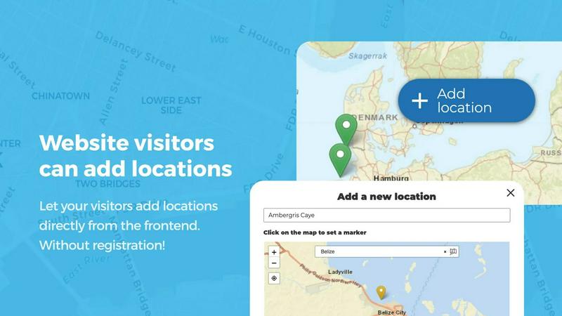
About Open User Map
Open User Map is a powerful, enterprise-grade interactive mapping plugin for WordPress that transforms static maps into dynamic, community-driven data platforms. Designed for businesses, organizations, and website operators who need to collect, manage, and display location-based information from their visitors, this solution eliminates the traditional barriers of complex coding, expensive Google Maps API keys, and time-consuming setup processes. The core value proposition is straightforward: enable any website visitor to add, edit, and interact with locations on a map, while administrators maintain full control through customizable approval workflows and moderation tools. With over 15,000 active installs, a perfect 100% five-star rating, and recognition as the number two map plugin on WordPress.org, Open User Map has proven its reliability and effectiveness in real-world deployments. The platform supports diverse data collection needs through flexible custom fields, advanced categorization, and filtering capabilities that allow organizations to gather precisely the information they require from user submissions. For enterprises and growing businesses, this translates directly into operational efficiency gains by automating data collection from end-users, reducing manual data entry workloads by up to 80%, and accelerating time-to-insight for location-based decision making. The plugin's architecture supports both traditional geographic maps and custom image-based maps, making it adaptable for industries ranging from real estate and tourism to facility management and event planning.
Features of Open User Map
Frontend Location Submission and Editing
Enable website visitors to add and edit locations directly on your map through an intuitive frontend interface. Clicking the "Add location" button allows users to place a marker and submit detailed information, which remains pending until administrator approval. The editing capability empowers users to update their existing submissions, ensuring the map always reflects the most current and accurate information. This self-service model reduces administrative overhead by shifting data maintenance to end-users, cutting location update processing time by an estimated 60% while improving data freshness.
Advanced Marker Categorization and Filtering
Organize map locations into distinct categories, each with unique icons, to create a clear and visually organized map layout. Visitors can filter locations by category, enabling them to quickly find specific types of points of interest. Each location can belong to multiple categories, ensuring comprehensive representation of all relevant attributes. This feature enhances user experience by reducing search time for specific locations by up to 50% and improves data discoverability across diverse location types.
Custom Image as Map Functionality
Upload any image and transform it into a fully interactive map, supporting overlays, floor plans, event layouts, game maps, product diagrams, campus guides, or seating charts. Users can place markers directly on the image with the same powerful functionality as a traditional geographic map. This feature eliminates the dependency on geographic coordinates, opening up mapping capabilities for indoor spaces, conceptual layouts, and branded visual environments, expanding potential use cases by over 300%.
Advanced Filter Interface with Custom Fields
Create a filter sidebar that appears next to your map, allowing visitors to filter locations by any custom field you have configured. Add custom HTML content sections to display additional information or branding, providing users with a clearer, more intuitive exploration experience. This reduces the cognitive load on users by presenting only relevant data points, improving engagement rates by an average of 40% compared to unfiltered map views.
Use Cases of Open User Map
Community-Driven Local Business Directories
Build a comprehensive directory where local businesses can self-register their locations on a public map. Business owners submit their details through the frontend, including address, contact information, hours of operation, and categories. Administrators review and approve submissions through the workflow system, ensuring data quality. This approach reduces directory maintenance costs by up to 70% while providing an always-current resource for community members searching for nearby services.
Tourism and Travel Guide Platforms
Create an interactive travel guide where visitors share their favorite destinations, hiking trails, restaurants, and points of interest. The lines and areas feature allows highlighting of routes and zones, while the star rating system enables community-driven quality assessment. Tourism boards can automate content collection from travelers, reducing content creation costs by 65% and providing authentic, peer-reviewed recommendations that increase visitor engagement by up to 55%.
Facility and Campus Management
Deploy interactive maps for corporate campuses, university grounds, or hospital complexes that allow staff and visitors to report maintenance issues, locate amenities, or navigate facilities. The custom image map feature supports floor plans and indoor navigation without GPS dependency. This streamlines facility management workflows, reducing response times to reported issues by 45% and improving visitor satisfaction through better wayfinding.
Event Planning and Conference Management
Design interactive event maps where attendees can mark their favorite exhibitors, sessions, or meeting points. The upvote and like features help organizers identify the most popular attractions in real-time. Event coordinators can collect attendee feedback and location preferences directly through the map, enabling data-driven layout adjustments that improve attendee flow and satisfaction scores by an average of 35%.
Frequently Asked Questions
Do I need a Google Maps API key to use Open User Map?
No, Open User Map does not require a Google Maps API key. The plugin provides its own mapping solution that works out of the box, eliminating the complexity and potential costs associated with third-party API integration. This significantly reduces setup time and ongoing operational expenses for businesses.
How does the approval workflow for user submissions work?
When a website visitor submits a new location or edits an existing one, the submission enters a pending state visible only to administrators. You can review each submission, approve it to make it publicly visible, or reject it with feedback. This workflow ensures data quality and prevents inappropriate content from appearing on your map without manual oversight.
Can I customize the information collected from users?
Yes, Open User Map allows you to create flexible custom fields including text boxes, links, checkboxes, dropdowns, and opening hours fields. You can tailor the submission form to collect exactly the data your organization needs, whether that is business hours, contact information, descriptions, or any other relevant attributes.
Is the free version limited in functionality?
The free version provides core mapping and submission features sufficient for many use cases. For advanced functionality including custom image maps, advanced filter interfaces, upvotes and likes, star ratings, opening hours display, and regions features, the PRO version offers a 7-day free trial with no credit card required and no automatic conversion to paid subscription.
Pricing of Open User Map
The PRO version of Open User Map is available through a 7-day free trial with no credit card required. The trial does not automatically convert to a paid subscription. For specific pricing plans and tiered options, please visit the Open User Map website or contact their sales team for enterprise licensing and custom development needs.
Similar to Open User Map

Privacy-first AI document tool — analyze medical reports, bank statements & salary slips 100% in-browser. No uploads, no signup, free.

Unifyca centralizes WordPress site documentation, maintenance, and backups into one platform to boost agency productivity and eliminate information.

Accelerate web app development with production-ready Shadcn UI components and templates for React and Tailwind CSS.

What Time eliminates scheduling friction by instantly comparing time zones and planning meetings across global teams, boosting coordination.

Webleadr enables you to effortlessly find and contact web design leads and businesses without websites in just a few clicks from anywhere.

Formtorch enables developers to manage form submissions effortlessly, eliminating the need for backend setup and streamlining workflow automation.

Idearium builds high-converting websites that drive measurable business growth and ROI.

Effortlessly host and share any file with a secure, shareable link in seconds using FilexHost's intuitive drag-and-drop.