
GeoRank
GeoRank combines 9 data layers and AI to rank global locations by tax, cost, and visa access, ending relocation research.
VisitPublished on:
July 13, 2026
Pricing:
About GeoRank
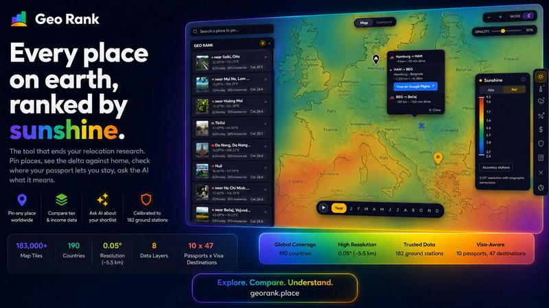
GeoRank is a free, no-signup interactive map platform that consolidates the fragmented relocation research process into a single, data-driven decision tool. Designed for professionals, digital nomads, and business leaders evaluating extended stays or permanent moves abroad, GeoRank eliminates the inefficiency of juggling a dozen disparate tabs for weather, cost of living, visa policies, and tax codes. The platform layers 8 distinct data sets over a global grid with approximately 5 km resolution, providing granular insights across 190 countries. Data sources include calibrated sunshine and temperature metrics from SARAH-3 satellite observations and ERA5 reanalysis, bias-corrected against 182 ground stations; tax rate data from OECD, PwC, and KPMG; visa and residency route information for 10 passports across 47 destinations; cost-of-living metrics from 478 cities; geopolitical risk assessments; and a community-sourced "Nomad Pulse" sentiment indicator. Users can pin up to 20 locations, compare them against a designated home base using relative deltas, and engage an AI assistant that reasons exclusively over the user's own shortlist to provide cited, grounded answers. GeoRank transforms raw data into actionable business intelligence for relocation, reducing research time from hours to minutes.
Features of GeoRank
Interactive Global Map with 9 Live Data Layers
Toggle and stack nine distinct data layers on a single interactive map, including sunshine hours, temperature, rainfall, outdoor hours, taxes, visas and residency options, cost of living, geopolitical risk, and Nomad Pulse community sentiment. Each layer is a live data source with transparent methodology, allowing users to pan globally and zoom down to approximately 5 km cells. The platform covers over 183,000 map tiles across 190 countries, providing enterprise-grade granularity for location intelligence.
Pin and Compare Mode with Home Baseline
Users can pin any location on the map, saving up to 20 places across browser sessions. The Compare mode allows users to set a home base as a baseline, then displays every metric as a relative delta against that home location. Instead of viewing absolute numbers, users see how much warmer, cheaper, safer, or differently taxed each candidate location is compared to their current reality. This feature enables rapid, apples-to-apples comparisons for relocation decision-making.
AI Assistant Reasoning Over Your Shortlist
The integrated AI chat operates exclusively on the user's pinned locations, not a generic knowledge base. Users can ask complex comparative questions like "Which of my 5 places has the best winter?" or "Score my shortlist: sunshine, cost, and low tax combined." The AI reasons across all pinned locations simultaneously, analyzing every metric to provide cited, grounded answers with source references. This eliminates the need for manual cross-referencing across multiple data sources.
Calibrated Data with Ground Truth Verification
Unlike raw satellite data that overestimates sunshine in cloudy regions, GeoRank merges SARAH-3 satellite observations with ERA5 reanalysis data, bias-corrected against 182 ground stations spanning Reykjavik to Phoenix to Sydney. The platform includes orographic terrain corrections for high-altitude locations and coastal microclimate adjustments. Sunshine data achieves approximately 8% accuracy in most locations, while temperature and rainfall data are calibrated against multiple ground-truth sources.
Use Cases of GeoRank
Relocation Research for Digital Nomads and Remote Workers
A freelancer on a UK passport evaluating Tbilisi versus Paphos can use GeoRank to compare sunshine hours, income tax rates, cost of living, and visa-free stay durations in a single interface. The platform reveals that Paphos meets a 2,800 sunshine hour threshold while Tbilisi falls short, but Tbilisi offers significantly lower monthly costs. The AI assistant synthesizes these trade-offs, enabling informed decisions within minutes rather than hours of manual research.
Corporate Global Mobility and Talent Relocation
Multinational corporations managing employee relocations can leverage GeoRank to evaluate multiple candidate cities against an employee's home base. HR teams can set the employee's current location as the baseline, then compare tax implications, cost-of-living adjustments, geopolitical risk, and climate differences across potential destinations. This streamlines the relocation package negotiation process with data-backed comparisons.
Investment and Real Estate Location Analysis
Real estate investors and property developers can use GeoRank to assess multiple regions for residential or commercial property investments. By layering sunshine, rainfall, geopolitical risk, and community sentiment data, investors can identify emerging markets with favorable conditions. The platform's ability to compare multiple locations simultaneously supports portfolio diversification strategies.
Retirement and Long-Term Stay Planning
Retirees and individuals planning extended stays abroad can use GeoRank to evaluate destinations against their specific criteria, such as low tax regimes, healthcare accessibility via visa routes, and climate preferences. The AI assistant can answer complex queries like "Which of my pinned places offers the best combination of low tax, warm winters, and visa-free access for my passport?" providing comprehensive, cited answers.
Frequently Asked Questions
How does GeoRank ensure data accuracy across different locations?
GeoRank employs a multi-source calibration methodology. Sunshine data from SARAH-3 satellite observations is bias-corrected against 182 ground stations worldwide, with orographic terrain corrections for high-altitude areas and coastal microclimate adjustments. Temperature data uses ERA5 reanalysis calibrated against ground stations, while tax data is sourced from OECD, PwC, and KPMG publications. Cost-of-living data comes from 478 cities, and visa information is verified against official government sources.
Is GeoRank free to use, and do I need to create an account?
GeoRank is completely free to use with no signup required. Users can access all 9 data layers, pin up to 20 locations, use Compare mode, and interact with the AI assistant without creating an account. Pinned locations are saved across browser sessions using local storage, so returning users will find their shortlist intact without any login requirements.
How does the AI assistant differ from generic chatbots?
The GeoRank AI assistant operates exclusively on the user's pinned locations and their associated data. It does not draw from a generic knowledge base or the broader internet. When a user asks "Which of my 5 places has the best winter?", the AI analyzes only the specific metrics for those locations, providing cited answers with source references. This ensures relevance and accuracy for the user's specific decision context.
What is the Nomad Pulse layer and how is it updated?
Nomad Pulse is a community-sourced sentiment indicator that tracks weekly sentiment from the digital nomad community. It processes social media posts and online discussions into signals categorized as rising, stable, or falling for each country and city. This layer provides real-time insight into where enthusiasm is building before it becomes mainstream, helping users identify emerging destinations.
Pricing of GeoRank
GeoRank is currently available as a completely free tool with no pricing tiers, subscription fees, or usage limits. All features including the interactive map, all 9 data layers, pin and compare functionality, and the AI assistant are accessible without payment or account creation. There is no premium version or paid upgrade available at this time.
Similar to GeoRank

Privacy-first, cookieless web analytics that ties your traffic and marketing channels to real Stripe revenue.

Signage and kiosk infrastructure for AI agents. Your agent publishes images, video, streams, web pages and apps to screens via one plugin.screenRIG is

A tray helper for every AI coding tool: one searchable library of past sessions, waiting alerts and usage across 9 providers.

Soul Cinema is a cinematic AI image generator that turns a written shot into a film-grade still, with Soul ID character consistency across a sequence,


Built2WinWeb is a custom PHP development studio and AI-native infrastructure provider.

